

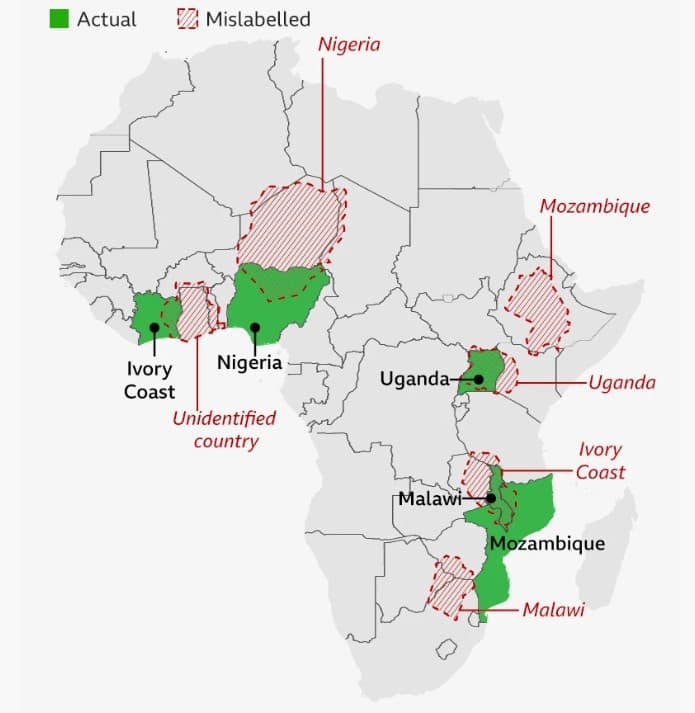
The United States State Department has issued a public apology after an AI-generated map of Africa displayed during a major international health conference incorrectly labelled and misplaced countries across the continent, sparking criticism from attendees and policy experts.
The incident occurred during a presentation at the AIDS 2026 Conference in Rio de Janeiro, where US officials were outlining health funding agreements with African nations. Screenshots of the presentation quickly circulated online after observers noticed significant geographical errors throughout the map.
According to analyses of the presentation, Nigeria was shown deep within the Sahara Desert, Mozambique appeared in the Horn of Africa, and Côte d’Ivoire was relocated to the eastern side of the continent. Several other countries were similarly misplaced or distorted. Reuters reported that the image contained a watermark indicating it had been created using OpenAI tools.
Responding to the backlash, the State Department acknowledged what it described as an “unfortunate error” and accepted responsibility for the mistake. A spokesperson said the map resulted from last-minute changes made to the presentation before the event.
In its official response, the department stated: “We take full responsibility for the confusion and misrepresentation it caused for attendees, including our African partners.”
The department added that the mistake was caused by a team member who had “hastily altered the slide deck” shortly before the conference presentation.
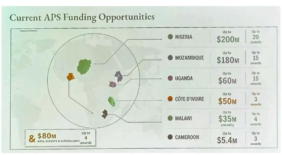
Despite the controversy, US officials maintained that discussions at the conference remained productive. The State Department described the engagement with African delegations as “substantive and constructive” and reiterated its commitment to global HIV/AIDS programmes.
The episode has reignited concerns about the reliability of generative artificial intelligence in high-profile and diplomatic settings. While AI tools are increasingly used to accelerate content creation, experts have repeatedly warned that they can produce convincing but inaccurate outputs — a phenomenon widely known as “hallucination”.
Critics argued that the errors should have been identified before the presentation reached an international audience. The incident also drew attention because the map was shown during discussions involving African governments and health partnerships, making geographical accuracy particularly important.
The State Department has not indicated whether new safeguards will be introduced for the use of AI-generated materials in future presentations. However, the incident is likely to become a prominent example of the reputational risks governments face when relying on artificial intelligence without sufficient human verification.
As governments, businesses and institutions continue to integrate AI into everyday operations, the Africa map controversy serves as a reminder that speed and convenience cannot replace basic fact-checking — particularly when diplomacy is involved.

Senior AI Writer
Bio: Okikiola is a writer and AI enthusiast with a background in Office Technology and Management from the Federal Polytechnic Offa. She went further to study an MSc in International Business at De Montfort University (DMU). With extensive work experience across administrative and business roles, she now focuses on exploring how artificial intelligence can transform work, innovation, and everyday life.